Selected Publications

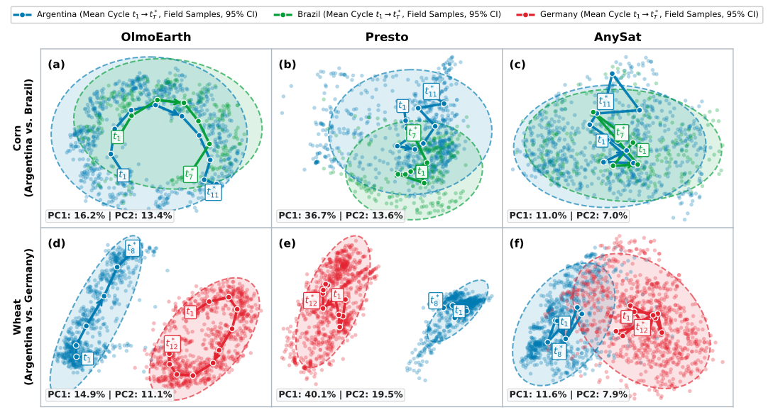
PCA temporal trajectories of OlmoEarth, Presto, and AnySat embeddings for corn and wheat fields

NeurIPS Workshop (REO) · 2026

Time, Space, and Modality: Probing Earth Foundation Models for Intra-Field Crop Yield Forecasting

A probe of four Earth foundation models (AlphaEarth, OlmoEarth, Presto, and AnySat) against a multi-view gated fusion baseline trained from scratch, testing whether their embeddings carry real crop phenology over time and preserve intra-field spatial variability, across 140 corn and 197 wheat field-years.

  • OlmoEarth with a ConvLSTM head achieves the highest field- and pixel-level R² on both crops (field R² = 0.614 corn, 0.863 wheat), benefiting from joint self-attention across space, time, and modality.
  • OlmoEarth overtakes AlphaEarth's frozen annual embedding about four months before corn harvest and five months before wheat harvest, tracing a genuine seasonal phenology cycle in embedding space.
  • AnySat, pretrained across 11 sensors, best preserves intra-field spatial autocorrelation (Moran's I), while OlmoEarth best recovers the yield distribution. Temporal fidelity and spatial detail come from distinct design choices.
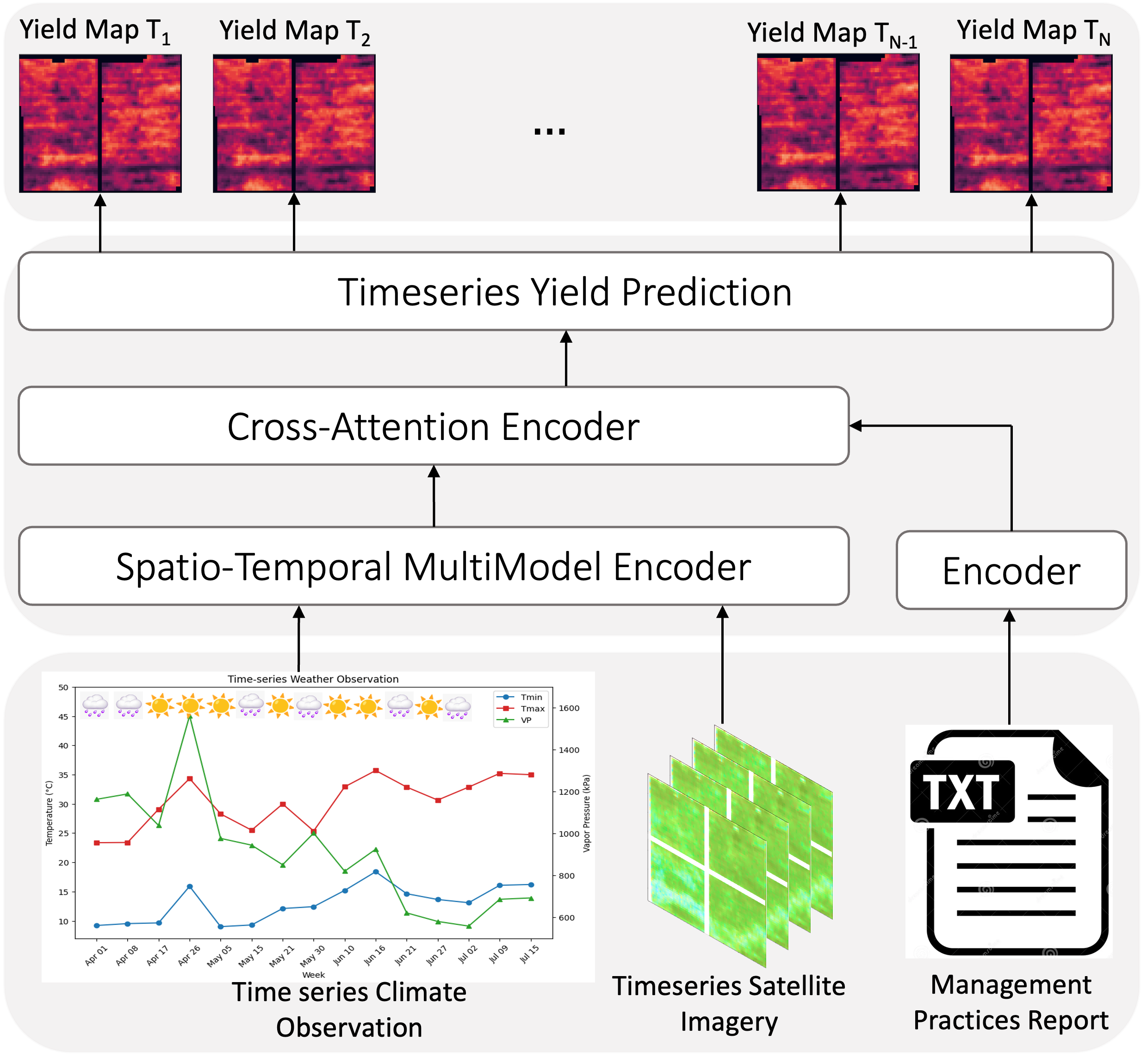
CMAViT multimodal architecture for crop yield prediction

IEEE JSTARS · 2026

CMAViT: Integrating Climate, Management, and Remote Sensing Data for Crop Yield Prediction With Multimodel Vision Transformers

A multimodal Vision Transformer that jointly encodes satellite time-series, seasonal climate, irrigation management records, and soil properties through cross-modal attention for vineyard and county-level yield prediction — now published in IEEE Journal of Selected Topics in Applied Earth Observations and Remote Sensing.

  • Achieved ~12% lower RMSE than single-modality baselines on California county-level grape yield prediction.
  • Cross-attention between climate and management tokens captures how irrigation decisions modulate heat-stress response — a relationship invisible to unimodal models.
  • Temporal ViT encoding preserves inter-annual variability patterns that recurrent baselines (LSTMs) systematically underfit.
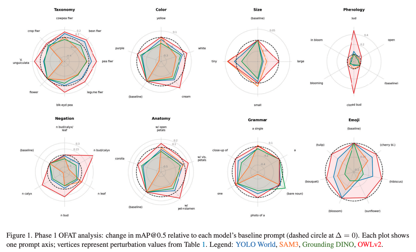
VFM results graph for botanical object detection

CVPRW · 2026

Does Your VFM Speak Plant? The Botanical Grammar of Vision Foundation Models for Object Detection

A systematic benchmark of Vision Foundation Models (VFMs) on agricultural object detection tasks, evaluating whether models pre-trained on general imagery understand the botanical grammar — texture, morphology, and structure — that defines plant species and growth stages.

  • VFMs trained on general image corpora exhibit a consistent botanical domain gap: they underperform specialist models on fine-grained plant detection tasks involving leaf topology and canopy structure.
  • Introduced a "botanical grammar" taxonomy — leaf morphology, branching patterns, and phenological cues — as a diagnostic framework for assessing VFM readiness in agricultural settings.
  • Targeted fine-tuning with botanical exemplars substantially closes the detection gap, demonstrating that VFMs can serve as strong backbones once domain-adapted.
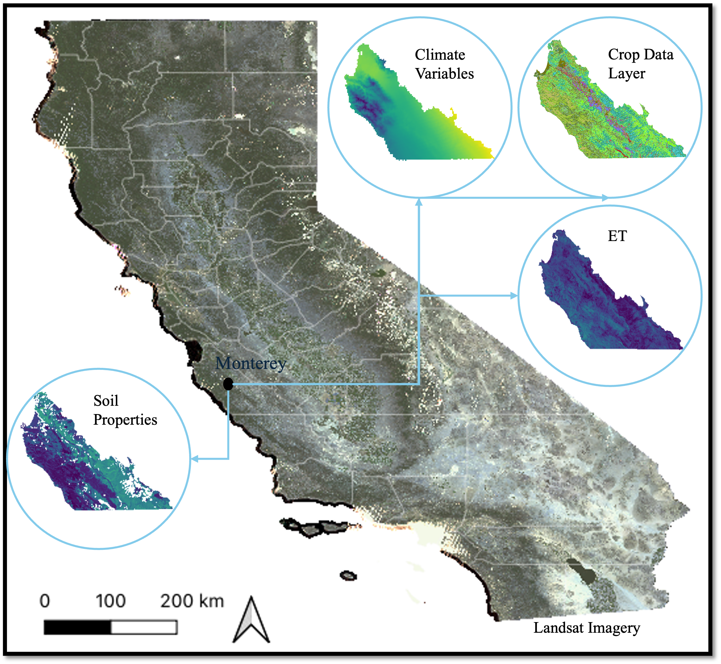
California crop yield benchmark overview

CVPR 2025

California Crop Yield Benchmark: Combining Satellite Image, Climate, Evapotranspiration, and Soil Data Layers for County-Level Yield Forecasting of Over 70 Crops

The first large-scale, openly available benchmark for California county-level crop yield forecasting, integrating satellite imagery, climate variables, evapotranspiration, and soil data across 70+ crops from 2008 to 2022.

  • Covers 70+ crops across all California counties for 15 growing seasons — the broadest scope of any public yield-forecasting benchmark.
  • Adding ET layers alongside satellite and climate inputs reduces prediction error by 9–18% across major row crops.
  • Benchmarks five ML architectures (CNN, LSTM, ViT, XGBoost, and hybrid) to establish reference accuracy scores for the research community.

All Publications & Talks

Follow on Google Scholar →

Peer-Reviewed & Preprint Publications

2026

  • Kamangir, H., Yun, H., & Earles, J.M., 2026. Time, Space, and Modality: Probing Earth Foundation Models for Intra-Field Crop Yield Forecasting. Proceedings of the NeurIPS 2026 Workshop on Representation Learning for Earth Observation (REO), Paris, France.
  • Kamangir, H., Berlingeri, J., Ranario, E., Uyehara, I.K., Lundqvist, L., Yun, H., Diepenbrock, C.H., Bailey, B.N., & Earles, J.M., 2026. Can Synthetic Data Overcome the Generalization Limits of AI-Based Flower and Pod Detection Across Cowpea Breeding Genotypes and Environments? arXiv:2607.28796.
  • Kamangir, H., Sams, B.S., Dokoozlian, N., Sanchez, L., & Earles, J.M., 2026. CMAViT: Integrating Climate, Management, and Remote Sensing Data for Crop Yield Prediction With Multimodel Vision Transformers. IEEE Journal of Selected Topics in Applied Earth Observations and Remote Sensing.
  • Lundqvist, L., Ranario, E., Kamangir, H., Yun, H., Diepenbrock, C., Bailey, B.N., & Earles, J.M., 2026. Does Your VFM Speak Plant? The Botanical Grammar of Vision Foundation Models for Object Detection. Proceedings of the IEEE/CVF Conference on Computer Vision and Pattern Recognition Workshops (CVPRW), 9768–9776.
  • Berlingeri, J.M., Lo, S., Riggs, M., Yun, H., Kamangir, H., Ranario, E., Uyehara, I.K., Mayanja, I., Lao, A., Dramadri, I.O., Ongom, P.O., et al., 2026. Genetic mapping and genomic prediction for agronomic, grain compositional, and sensing-enabled traits in a cowpea MAGIC population along an environmental gradient. bioRxiv preprint.

2025

  • Kamangir, H., Hajiesameeli, M., & Earles, J.M., 2025. California Crop Yield Benchmark: Combining Satellite Image, Climate, Evapotranspiration, and Soil Data Layers for County-Level Yield Forecasting of Over 70 Crops. IEEE/CVF Conference on Computer Vision and Pattern Recognition (CVPR).
  • Kamangir, H., Sams, B.S., Dokoozlian, N., Sanchez, L., & Earles, J.M., 2025. Predicting crop yield lows through the highs via binned deep imbalanced regression: A case study on vineyards. International Journal of Applied Earth Observation and Geoinformation, 139, 104536.
  • Kamangir, H., Sams, B.S., Dokoozlian, N., Sanchez, L., & Earles, J.M., 2025. CMAViT: Integrating Climate, Management, and Remote Sensing Data for Crop Yield Estimation with Multimodal Vision Transformers. arXiv:2411.16989.

2024

  • Kamangir, H., Krell, E., Collins, W., King, S.A., & Tissot, P., 2024. FogNet-v2.0: Explainable Physics-Informed Vision Transformer for Coastal Fog Forecasting. ESS Open Archive, 327, 172191653-32706065.
  • Kamangir, H., Sams, B.S., Dokoozlian, N., Sanchez, L., & Earles, J.M., 2024. Large-scale spatio-temporal yield estimation via deep learning using satellite and management data fusion in vineyards. Computers and Electronics in Agriculture, 216, 108439.
  • Bafti, A.G., Ahmadi, A., Abbasi, A., Kamangir, H., Jamali, S., & Hashemi, H., 2024. Automated actual evapotranspiration estimation: Hybrid model of a novel attention-based U-Net and metaheuristic optimization algorithms. Atmospheric Research, 297, 107107.

2023

  • Krell, E., Kamangir, H., Collins, W., King, S.A., & Tissot, P., 2023. Aggregation strategies to improve XAI for geoscience models that use correlated, high-dimensional rasters. Environmental Data Science, 2, e45.

2022

  • Vicens-Miquel, M., Medrano, F.A., Tissot, P.E., Kamangir, H., Starek, M.J., & Colburn, K., 2022. A deep learning based method to delineate the wet/dry shoreline and compute its elevation using high-resolution UAS imagery. Remote Sensing, 14(23), 5990.
  • Ghamari, M., Kamangir, H., Arezoo, K., & Alipour, K., 2022. Evaluation and calibration of low-cost off-the-shelf particulate matter sensors using machine learning techniques. IET Wireless Sensor Systems, 12(5-6), 134-148.
  • Kamangir, H., Krell, E., Collins, W., King, S.A., & Tissot, P., 2022. Importance of 3D convolution and physics on a deep learning coastal fog model. Environmental Modelling & Software, 105424.
  • Vicens-Miquel, M., Medrano, F.A., Tissot, P., Kamangir, H., & Starek, M., 2022. Deep learning automatic detection of the wet/dry shoreline at Fish Pass, Texas. IGARSS 2022 IEEE International Geoscience and Remote Sensing Symposium, 1876-1879.

2021

  • Raja, P., Olenskyj, A., Kamangir, H., & Earles, M., 2021. Simultaneously predicting multiple plant traits from multiple sensors via deformable CNN regression. arXiv:2112.03205.
  • Alizadeh, B., Bafti, A.G., Kamangir, H., Zhang, Y., Wright, D.B., & Franz, K.J., 2021. A novel attention-based LSTM cell post-processor coupled with Bayesian optimization for streamflow prediction. Journal of Hydrology, 601, 126526.
  • Kamangir, H., Collins, W., Tissot, P., King, S.A., Dinh, H.T.H., Durham, N., & Rizzo, J., 2021. FogNet: A multiscale 3D CNN with double-branch dense block and attention mechanism for fog prediction. Machine Learning with Applications, 100038.
  • Sharafi, S., Kamangir, H., King, S.A., & Safaierad, R., 2021. Effects of extreme floods on fluvial changes: the Khorramabad River as case study (western Iran). Arabian Journal of Geosciences, 14(12), 1140.
  • Barzin, R., Kamangir, H., & Bora, G.C., 2021. Comparison of machine learning methods for leaf nitrogen estimation in corn using multispectral UAV images. Transactions of the ASABE, 64(6), 2089-2101.

2020

  • Noori, F., Kamangir, H., King, S.A., Sheta, A., Pashaei, M., & SheikhMohammadZadeh, A., 2020. A deep learning approach to urban street functionality prediction based on centrality measures and stacked denoising autoencoder. ISPRS International Journal of Geo-Information, 9(7), 456.
  • Pashaei, M., Starek, M.J., Kamangir, H., & Berryhill, J., 2020. Deep learning-based single image super-resolution: an investigation for dense scene reconstruction with UAS photogrammetry. Remote Sensing, 12(11), 1757.
  • Kamangir, H., Collins, W., Tissot, P., & King, S.A., 2020. Deep-learning model used to predict thunderstorms within 400 km² of south Texas domains. Meteorological Applications, 27(2).
  • Pashaei, M., Kamangir, H., Starek, M.J., & Tissot, P., 2020. Review and evaluation of deep learning architectures for efficient land cover mapping with UAS hyper-spatial imagery: A case study over a wetland. Remote Sensing, 12(6), 959.

2018

  • Kamangir, H., Rahnemoonfar, M., Dobbs, D., Paden, J., & Fox, G., 2018. Deep hybrid wavelet network for ice boundary detection in radar imagery. IGARSS 2018 IEEE International Geoscience and Remote Sensing Symposium, 3449-3452.
  • Kamangir, H., Rahnemoonfar, M., Dobbs, D., Paden, J., & Fox, G., 2018. Detection ice layers in RADAR images with deep learning. IGARSS 2018 IEEE International Geoscience and Remote Sensing Symposium.

2017

  • Kamangir, H., Momeni, M., & Satari, M., 2017. Automatic centerline extraction of covered roads by surrounding objects from high resolution satellite images. The International Archives of the Photogrammetry, Remote Sensing and Spatial Information Sciences, 42, 111-116.

Technical & Oral Presentations

2026

  • Lundqvist, L., Ranario, E., Kamangir, H., Yun, H., Diepenbrock, C., Bailey, B.N., & Earles, J.M., 2026. Does Your VFM Speak Plant? The Botanical Grammar of Vision Foundation Models for Object Detection. IEEE/CVF CVPR Workshop on Vision for Agriculture (V4A), June.

2025

  • Kamangir, H., Hajiesameeli, M., & Earles, J.M., 2025. California Crop Yield Benchmark: Combining Satellite Image, Climate, Evapotranspiration, and Soil Data Layers for County-Level Yield Forecasting of Over 70 Crops. CVPR, June.
  • Colburn, B., Collins, W.G., Tissot, P.E., Williams, J.K., King, S.A., Krell, E., Gaudet, L., Kamangir, H., & White, M.C., 2025. A VAE for Coastal Airport Visibility Predictions: Architecture, Performance and R2X Potential. 105th AMS Annual Meeting, January.

2024

  • Wirz, C.D., Demuth, J.L., White, M., Radford, J.T., Tissot, P.E., Cains, M.G., Kamangir, H., Krell, E.A., Bostrom, A., King, S.A., & Collins, W.G., 2024. NWS forecaster perceptions of new AI guidance for coastal fog prediction. 104th AMS Annual Meeting, January.

2022

  • Vicens Miquel, M., Medrano, F.A., Tissot, P., Kamangir, H., & Starek, M., 2022. Generalized model for wet/dry shoreline detection and total water level elevation using deep learning. AGU Fall Meeting, December.

2021

  • Kamangir, H., Collins, W.G., King, S.A., Tissot, P., Durham, N., & Rizzo, J., 2021. FogNet: A Multiscale 3D CNN with an Attention Mechanism and a Dense Block for Fog Forecasting. 101st AMS Annual Meeting, January. [Third Place Best Student Oral Presentation]

2020

  • Kamangir, H., Tissot, P.E., Collins, W.G., & King, S.A., 2020. A Comparison of Deep Learning, Shallow Neural Networks, and Principal Component Analysis Based Approaches to Thunderstorm Prediction. 100th AMS Annual Meeting, January.

2018

  • Kamangir, H., Rahnemoonfar, M., Dobbs, D., Paden, J., & Fox, G., 2018. Detecting ice layers in radar images with deep learning. IGARSS 2018 IEEE International Geoscience and Remote Sensing Symposium.